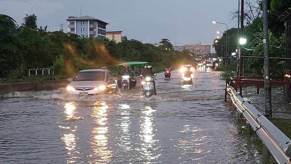
The Meteorological Department forecasts that some areas in Thailand will experience heavy rainfall, urging residents in these regions to be cautious of potential dangers such as flash floods and forest runoff. Meanwhile, Bangkok and its surrounding areas are expected to have thunderstorms covering 80% of the area, with heavy rain in some parts.
For the next 24 hours, the southwest monsoon covering the Andaman Sea, western Thailand, and the Gulf of Thailand is intensifying. Additionally, a low-pressure system is covering the lower northern and upper central regions of Thailand. This weather pattern will result in heavy rainfall in some areas of Thailand. Residents in these areas are advised to be cautious of the dangers posed by heavy and accumulated rainfall, which may cause flash floods and forest runoff, especially in foothill areas near waterways and low-lying areas. Increased caution is also advised for those traveling through areas experiencing thunderstorms.
The upper Andaman Sea will have fairly strong waves, while the lower Andaman Sea and the Gulf of Thailand will have moderate waves. In the upper Andaman Sea, waves will be 2-3 meters high, and more than 3 meters in areas with thunderstorms. In the lower Andaman Sea, waves will be 1-2 meters high, and over 2 meters in areas with thunderstorms. In the Gulf of Thailand, waves will be about 1 meter high, and 1-2 meters offshore, with waves over 2 meters in thunderstorm areas. Mariners in the Andaman Sea and the Gulf of Thailand are advised to proceed with caution and avoid sailing in thunderstorm areas. Mariners in the upper Andaman Sea should refrain from going offshore.
Additionally, a strong low-pressure system in the lower Bay of Bengal is likely to intensify into a depression on May 23-24, and is expected to make landfall in northeastern India and Bangladesh on May 25-26. This storm will not directly affect Thailand’s weather but will strengthen the southwest monsoon over the Andaman Sea, western Thailand, and the Gulf of Thailand. Consequently, from May 23-24, Thailand will experience heavy rainfall in many areas, with very heavy rain in some parts.
During May 23-26, the upper Andaman Sea will have fairly strong waves, 2-3 meters high, and more than 3 meters in areas with thunderstorms. The lower Andaman Sea will have waves about 2 meters high, and over 2 meters in areas with thunderstorms. The Gulf of Thailand will have waves about 1 meter high, and 1-2 meters offshore, with waves over 2 meters in thunderstorm areas. Mariners in the Andaman Sea and the Gulf of Thailand should proceed with caution and avoid sailing in thunderstorm areas. Mariners in the upper Andaman Sea should refrain from going offshore during May 23-26.
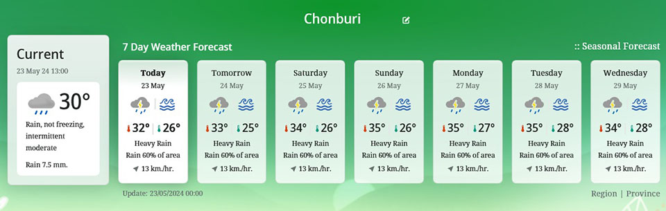
For Bangkok and its vicinity, thunderstorms are expected in 80% of the area, with heavy rain in some parts. The minimum temperature will be 26-27°C, and the maximum temperature will be 32-35°C.


