Weather forecast for the East of Thailand
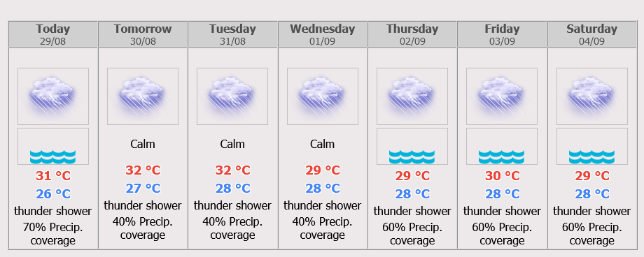
Fairly widespread thundershowers and isolated heavy rains in Nakhon Nayok, Prachin Buri, Sa Kaeo, Chachoengsao, Chon Buri, Rayong, Chanthaburi and Trat. Minimum temperature 22-24 °C. Maximum temperature 29-32 °C. Southwesterly winds 15-35 km/hr. Wave height 1-2 meters and above 2 meters in thundershowers.
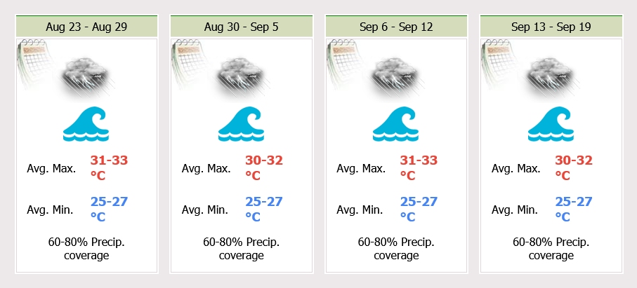
Scattered to fairly widespread thundershowers throughout the period and isolated heavy to very heavy rains during 31 Aug – 4 Sep. Minimum temperature 23-26°C. Maximum temperature 30-33°C. During 30 – 31 Aug, Southwesterly wind 15-30 km/hr. Wave height about 1 meter and 1- 2 meters in thundershowers. During 1 – 4 Sep, Southwesterly wind 15-35 km/hr. Wave height 1 – 2 meters and above 2 meters in thundershowers.
The monsoon trough lies across the Central, the East and the lower Northeast regions into the low-pressure cell over the lower South China Sea. In addition, the moderate southwest monsoon prevails across the Andaman Sea, Thailand and the Gulf of Thailand.
In the country, persistent rainfall will be likely, as well as isolated heavy rain in the North, the Northeast, the Central and the East. People in risky areas should beware of the severe condition and its accumulation that may cause overflows and flash floods. In the upper Andaman Sea and the upper Gulf of Thailand waves height 1-2 meters high and in thundershowers higher than 2 meters high. All ships should proceed with caution.
During 30 – 31 Aug, the monsoon trough lies across the lower North, the Central, the East and the Northeast while the southwest monsoon prevails over the Andaman Sea, Thailand and will be weakening.
Isolated heavy rain is likely in the lower North, the Central and the East. During 1 – 4 Sep, the monsoon trough lies across the North and the Northeast. The southwest monsoon prevailing over the Andaman Sea, Thailand and the Gulf of Thailand will be stronger with thundershower over Thailand while isolated heavy to very heavy rain in the North, the Northeast, the Central, the East. and the South (west coast). The moderate wind and waves over the Andaman Sea and the upper Gulf of Thailand will be likely 1-2 meters and above 2 meters in thundershowers.
 |
 |
 |


