A day after officials promised that a massive oil spill in Rayong wouldn’t reach shore, the slick had grown to nine times the size of Koh Samet and will hit Rayong beaches today.
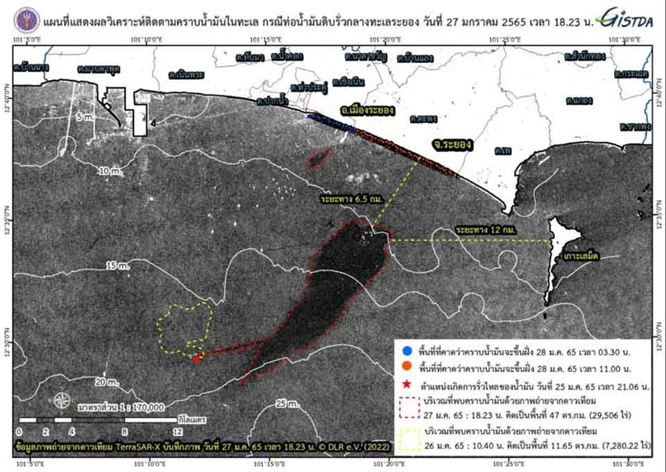
A satellite photo supplied by the Geo-Informatics and Space Technology Development Agency showed the slick from a leaking underwater pipeline in Maptaput Bay covered 47 sq. kilometers, nine times bigger than Koh Samet.
GISTDA released the picture taken by the TerraSAR-X satellite at 6:23 p.m. on Jan. 27 as it followed the crude from a loading buoy about 20 kilometers southeast of the Maptaphut port on Jan. 25.
Last night the oil was about 6.5 kilometers from Rayong’s Muang District and about 12 kilometers from Koh Samet.
The slick was moving northeasterly and expected to wash ashore today, impacting the coast in Muang District, the Mae Ramphueng beach and nearby beaches.
Just yesterday, the Industrial Estate Authority of Thailand and environmental agencies predicted the oil would not wash ashore like what had happened in 2013.
Officials claimed – falsely – that emergency teams had successfully contained the oil within an area of about one square kilometer. The satellite photo made fools of that statement.
IEAT Gov. Veeris Ammarapala said the leakage happened to an undersea pipeline and had nothing to do with any pipe receiving oil from a tanker. The cause of the leakage was under investigation.
Dispersants were sprayed on two oil slicks totaling about 160,000 liters.
The original version of this story appeared in the Bangkok Herald, a Pattaya Mail partner.
 |
 |
 |


