Weather Warning Announcement

“Summer Thunderstorm in upper Thailand”
No. 3 Time Issued: March 19, 2020
From 20 – 23 March, the westerly trough will move through the North to the Northeast while the southerly and the southeasterly winds blows with the humidity from the South China Sea into the lower Northeast, the East and the Central regions where the heat low rules. Outbreaks of summer storms will be forecast with gusty winds, hail and lighting strikes in some portions of the upper country. People should beware of severe weather by keeping off unsecured buildings and outdoor places. Farmers should prevent for crop damage.
Affected areas are as follows: 20-21 March 2020
North: Tak, Kamphaeng Phet, Sukhothai, Phrae, Lamphun, Lampang, Nan, Uttaradit, Phitsanulok, Phichit and Phetchabun
Northeast: Loei, Nong Bua Lam Phu, Nong Khai, Udon Thani, Bueng Kan, Sakon Nakhon, Nakhon Phanom, Mukdahan, Khon Kaen, Chaiyaphum, Nakhon Ratchasima, Maha Sarakham, Kalasin, Roi Et, Yasothon, Amnat Charoen, Buriram, Surin, Sisaket and Ubon Ratchathani
East: Nakhon Nayok, Prachin Buri, Sa Kaeo, Chachoengsao, Chon Buri, Rayong, Chantapri and Trat
Central: Kanchanaburi, Suphan Buri, Uthai Thani, Chai Nat, Sing Buri, Ang Thong, Nakhon Sawan, Lop Buri, Saraburi and Phra Nakhon Si Ayutthaya.
22-23 March 2020
North: Nan, Uttaradit, Phitsanulok, Phichit and Phetchabun
Northeast: Loei, Nong Bua Lam Phu, Nong Khai, Udon Thani, Bueng Kan, Sakon Nakhon, Nakhon Phanom, Mukdahan, Khon Kaen, Chaiyaphum and Nakhon Ratchasima
East: Nakhon Nayok, Prachin Buri, Sa Kaeo, Chachoengsao, Chon Buri, Rayong, Chantapri and Trat
Central: Chai Nat, Sing Buri, Ang Thong, Nakhon Sawan, Lop Buri and Saraburi
The advisory is in effect on 19 March 2020, at 5.00 p.m.
This next issue will be at 20 March 2020, at 5.00 a.m.
(Signed) Gp.Capt. Somsak Khaosuwan
(Somsak Khaosuwan)
Director-General
Thai Meteorological Department
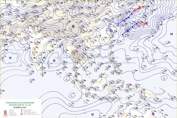
General Situation
The heat low covers upper Thailand while the southerly and southeasterly coming with the humidity from the South China Sea into the Northeast, the East and the Central regions. Meanwhile, the South gets easterly winds across the Gulf, and the westerly trough is going to blow into the North tomorrow (20 March).
Chiang Mai – Weather Forecast
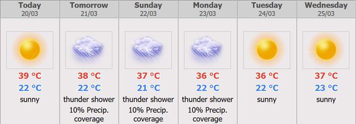
In the upper Thailand, hot condition covers all while outbreaks of summer storms are possible with thundershowers, gusty wind and hail in some parts of the North and the Central regions including Bangkok and its vicinity. People should keep off unsecured building and outdoor places while farmers beware of crop damage.
Dust situation: The weak southerly and southwesterly winds across Bangkok and its vicinity bring about less accumulation of dust/smog. In the upper North, more accumulation is forecast in the morning due to bad ascending of air-parcel.
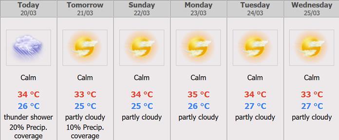
Pattaya – Weather Forecast
During 20 – 23 Mar, the westerly trough will move through the North and the Northeast with the southerly and the southeasterly wind prevails over the upper country where hot to very hot weather conditions. Thunderstorm with gusty wind and isolated hails are forecast for the North, the Northeast, the Central and the East including Bangkok and vicinity. The easterly prevailing the South and the Gulf will strengthen and cause more rain in the South. During 24 – 25 Mar, the heat low covers upper Thailand with hot to very hot in the upper country. The Southerly and Southeasterly wind brings moisture to the Northeast East, the Central ant the East with isolated thundershowers. The weak easterly wind prevails across the South and the Gulf with isolated rain over the South.
Cautions
During 20 – 23 Mar, people in upper Thailand should beware of severe conditions.
 |
 |
 |


