PATTAYA, Thailand – Assoc. Prof. Dr. Seri Supharathit, Director of the Climate Change and Disaster Center at Rangsit University and Vice President of the National Disaster Warning Foundation, posted on Facebook this morning (Nov 5, 2025) regarding the impact of Typhoon Kalmaegi on Thailand. He urged the public to maintain the highest level of alert from November 7–10.
The National Disaster Warning Center of the Department of Disaster Prevention and Mitigation has been closely monitoring Typhoon Kalmaegi. The storm is expected to strengthen into a severe typhoon by tomorrow, November 6, before making landfall in central Vietnam near Quang Ngai Province on Thursday night (Nov 6). It is expected to gradually weaken afterward.
“I am currently in Uttaradit, where the weather is unusually hot instead of cooling down, indicating that high atmospheric pressure will not disperse this storm,” said Dr. Seri.
Areas marked in yellow and orange within red frames (stretching from northwest to southeast) are expected to face severe impacts from heavy rainfall, with accumulated rainfall over 300mm within two days. These conditions pose a high risk of flooding, overflowing rivers, and flash floods. Authorities are urged to maintain the highest level of preparedness.

Starting the morning of November 7, central and lower northeastern provinces—including Ubon Ratchathani, Sisaket, Surin, Buriram, Amnat Charoen, Yasothon, Roi Et, Maha Sarakham, Kalasin, and Mukdahan—are at high risk. The storm will reach northern provinces such as Nan, Phrae, and Uttaradit on November 8 and many central provinces by November 10. Local authorities are advised to set up war rooms, closely coordinate with the National Disaster Warning Center, and issue timely alerts to residents.
eam areas in the northeastern (e.g., Ubon Ratchathani) and central (e.g., Ayutthaya) regions may experience multiple flood waves as rainfall moves from downstream to upstream areas (such as the Mun and Chi river basins, and the Chao Phraya basin). Many reservoirs in the north and northeast are already at critical levels, and dam operators are urged to manage risks at the highest level.
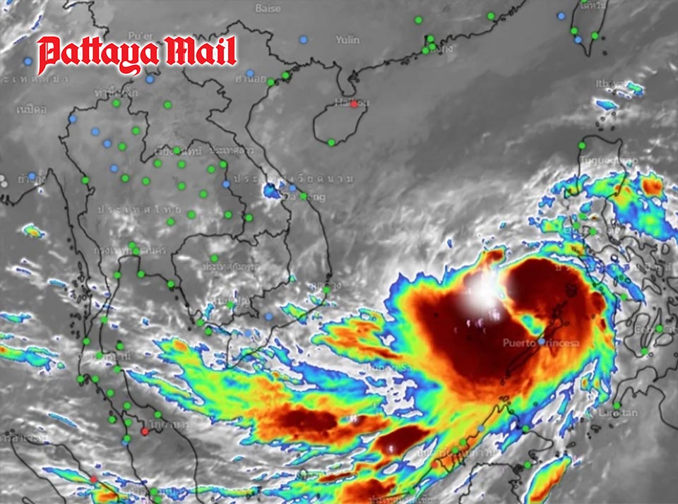
The Facebook page Weather Alert updated satellite images at 9:00 a.m. today (Nov 5, 2025), showing Typhoon Kalmaegi in the lower South China Sea, intensifying continuously. The storm is expected to make landfall in central Vietnam tomorrow evening (Nov 6, 2025).
The projected path shows the storm passing through central Vietnam, southern Laos, and northeastern Thailand (Ubon Ratchathani and Amnat Charoen) as a tropical depression, dissipating in the lower northern region near Tak Province. Between November 7–9, northern and central Thailand will experience thunderstorms, strong winds, and very heavy rainfall along the storm’s path.


