
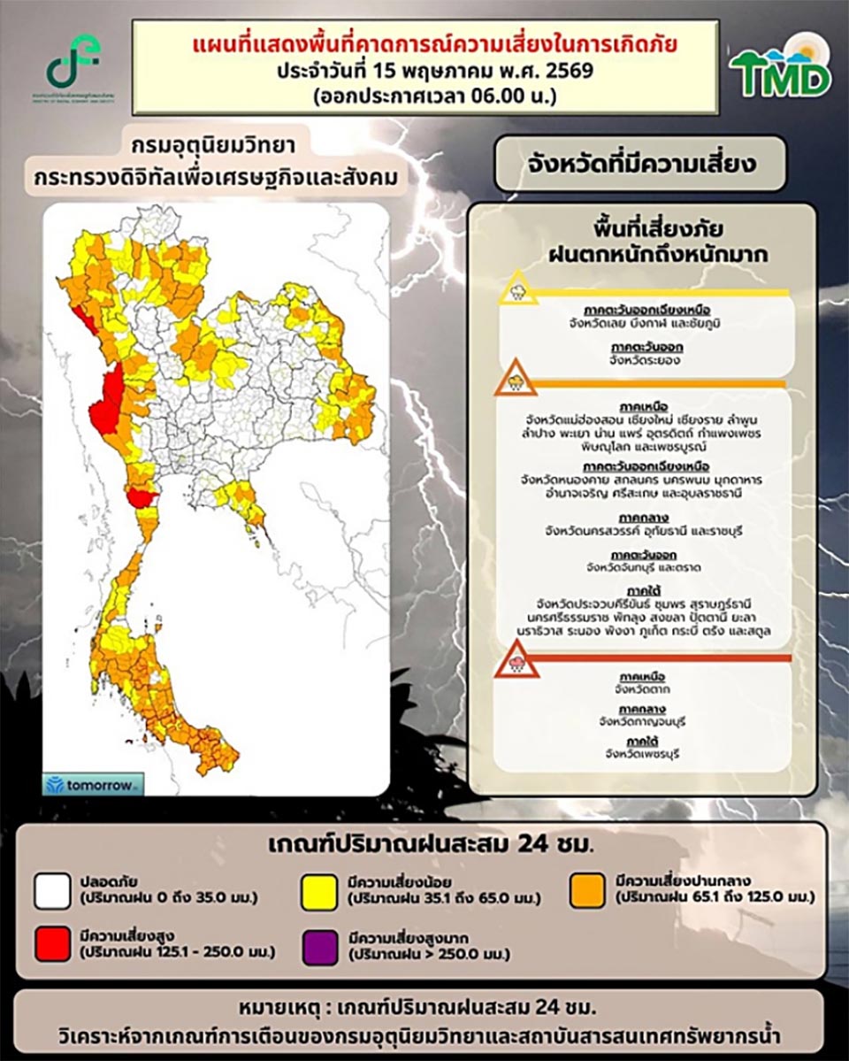
PATTAYA, Thailand – The Thai Meteorological Department (TMD) has officially announced that Thailand has entered the rainy season, while also issuing its fifth weather warning for heavy to very heavy rainfall and strong winds over the Andaman Sea, with high-risk and moderate-risk alerts covering dozens of provinces nationwide. In the next 24 hours, rainfall is expected to increase across the country, with some areas—particularly western regions—likely to experience heavy downpours due to a strengthening southwest monsoon affecting the Andaman Sea, Thailand, and the Gulf of Thailand. Authorities have warned of possible flash floods, runoff, and overflowing waterways, especially in low-lying and hillside areas.
Farmers have been advised to strengthen fruit trees and protect agricultural products and livestock from potential damage, while the public is urged to take care of their health during rapidly changing weather conditions. Sea conditions in the upper Andaman Sea are expected to be moderate, with waves around 2 meters and higher during thunderstorms. Small boats are advised to exercise extreme caution or remain ashore during adverse weather.
The TMD’s seven-day outlook (May 16–21) indicates widespread heavy to very heavy rainfall across Thailand as the southwest monsoon strengthens. The southern region is also expected to see increased rainfall and rough sea conditions, with waves reaching 2–3 meters in the upper Andaman Sea and around 2 meters in the upper Gulf of Thailand, rising higher during storms. Authorities have warned residents nationwide to remain alert for flash floods, landslides, and river overflow caused by accumulated rainfall, while urging fishermen and boat operators to avoid sailing during thunderstorms. Small craft in the upper Andaman Sea are advised to stay ashore during the period.
Meanwhile, weather monitoring pages have highlighted model forecasts suggesting a high risk of widespread flooding between May 16–22, with peak intensity expected around May 18–20, particularly in western regions, the upper north, upper northeast, central west, and eastern provinces including Rayong, Chanthaburi, and Trat, as well as southern areas. Officials continue to urge the public to closely monitor updates and follow official advisories as severe weather conditions are expected to persist.


