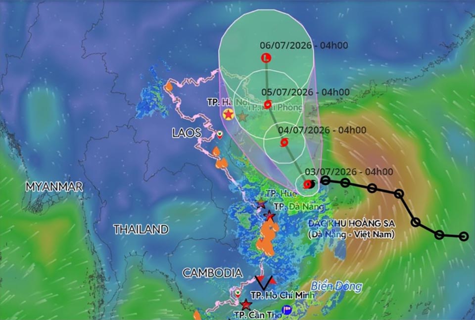
HANOI, Vietnam – Tropical Storm Maysak, the first storm to enter the eastern Vietnam Sea this year, is tracking slowly northwestward toward China’s Hainan Island and the northern coast of Vietnam, bringing warnings of strong winds, heavy rainfall, high waves and possible coastal flooding. At 7.00 a.m. on Friday, July 3, the storm’s centre was located over waters northwest of Vietnam’s Hoang Sa Special Zone, about 140 kilometres southeast of Hainan Island, moving slowly northwest at around 5 km/h, according to the National Centre for Hydro-Meteorological Forecasting. Maximum sustained winds near the storm’s centre were recorded at 62–74 km/h, with gusts reaching up to 102 km/h.
Forecasters said Maysak is expected to continue moving northwest at 10–15 km/h over the next 24 hours, strengthening its impact as it approaches Hainan Island before entering the Gulf of Tonkin.
By Saturday afternoon (4), the storm is forecast to be over the eastern Gulf of Tonkin, maintaining wind speeds of around 74 km/h with gusts up to 102 km/h, as it edges closer to Vietnam’s northeastern coastline. Authorities expect the storm to continue its trajectory toward the coastal provinces of Quang Ninh and the port city of Hai Phong, with land interaction likely by early Sunday (5). Meteorologists warned that Maysak may make landfall between Quang Ninh in Vietnam and Guangxi in southern China before weakening into a tropical depression and eventually dissipating into a low-pressure system.
Vietnamese weather officials have warned that northern waters of the eastern Vietnam Sea, including the Hoang Sa area, will experience dangerous conditions, with wind speeds reaching 74 km/h and gusts up to 102 km/h. Wave heights are forecast to reach 2–5 metres. In the Gulf of Tonkin, winds are expected to strengthen from Saturday night, with wave heights of 2–4 metres, posing risks to maritime activity. Along the coast from Quang Ninh to Hung Yen, waves may reach 2–3 metres, with storm surge potentially raising sea levels by 0.2–0.3 metres. Authorities have warned that fishing vessels, offshore aquaculture farms, sea dykes, coastal roads and marine infrastructure could be severely affected. Officials said vessels and coastal facilities face risks of capsizing, damage and flooding due to strong winds, thunderstorms, possible tornadoes and high waves.
Inland areas of northeastern Vietnam are also expected to experience winds of up to 28 km/h, with gusts reaching 74 km/h, alongside thunderstorms and potential localized severe weather.
Heavy rainfall is forecast from Friday night through Sunday across northeastern provinces and parts of northern central Vietnam, with totals of 100–200 mm expected, and some areas possibly exceeding 350 mm, raising concerns over flash flooding and landslides in vulnerable regions.


