

BANGKOK, Thailand – The World Meteorological Organization (WMO) is warning that El Niño is strengthening rapidly and could develop into a very strong event before reaching its peak toward the end of 2026, raising the risk of extreme heat, drought and flooding in many parts of the world.
In its latest El Niño/La Niña Update released on September 3, the WMO said forecasts from its Global Producing Centres indicate an exceptionally high likelihood of nearly 100% that El Niño will persist through February 2027. The agency said this is the first time one of its updates has expressed such a high level of certainty, reflecting strong agreement among forecasting systems.
WMO Secretary-General Celeste Saulo said communities and economies are already experiencing disruption from droughts and floods, with the impacts expected to increase as the El Niño event strengthens. The phenomenon is being driven by exceptionally warm waters across the tropical Pacific. Sea surface temperatures in the central and eastern equatorial Pacific have continued to rise, with the latest observations showing strong and mutually reinforcing oceanic and atmospheric signals.
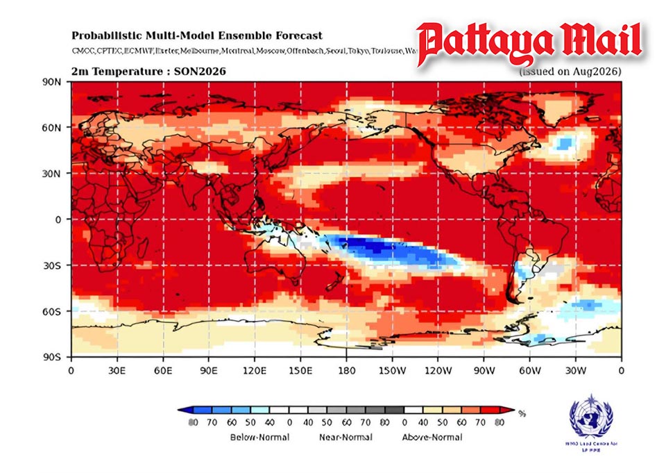
The Niño 3.4 region, a key indicator used to monitor El Niño, recorded sea surface temperatures significantly above normal during recent months. WMO forecasts indicate that the event could strengthen further to very strong intensity before peaking toward the end of the year, with its effects continuing into 2027. For September-November 2026, WMO multi-model forecasts indicate an increased likelihood of above-normal temperatures across almost all land areas. Rainfall patterns are also expected to show the typical atmospheric response associated with a strong Pacific El Niño.
The agency warned that a very strong El Niño can significantly alter rainfall, temperatures and atmospheric circulation, increasing the likelihood of extreme heat, drought and flooding in different parts of the world. However, WMO stressed that the strength of El Niño alone does not determine how severe conditions will be in any particular country. Impacts vary by location and season and can be modified by other climate drivers, including conditions in the Indian and Atlantic oceans.
A positive Indian Ocean Dipole is also expected to develop, while the tropical Atlantic is forecast to remain generally warmer than normal. These additional climate patterns could reinforce, weaken or alter the typical effects of El Niño in different regions. The WMO is therefore working with national meteorological and hydrological services, United Nations agencies and humanitarian organizations to strengthen preparedness and early-warning systems.
Saulo said the information can help governments and affected sectors make decisions before extreme conditions occur, including planning for agriculture, water resources, energy, health and disaster management. The WMO said its El Niño forecasts are designed to help governments and decision-makers prepare for climate-related impacts. The agency emphasized that El Niño does not inevitably result in disaster and that early action can help protect lives, livelihoods and economies. (TNA)