
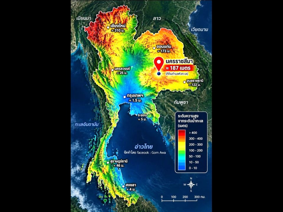
BANGKOK, Thailand – Thailand is not a flat country, and differences in elevation can provide useful clues about how water moves across different areas, particularly during periods of heavy rain and flooding. Much of northeastern Thailand sits on the Khorat Plateau, a large elevated region covering about 150,000 square kilometers. Much of the plateau lies roughly 130–250 meters above mean sea level.
Nakhon Ratchasima, the largest province in the Northeast, has an average elevation of about 187 meters above mean sea level, according to provincial information. Looking at Thailand’s topography shows that the country has considerable variations in elevation. The Central Plain contains extensive low-lying areas, while much of the Northeast rises onto the Khorat Plateau. But being on higher ground does not mean an area cannot flood.
Elevation can help explain some types of flood and water-level risk, including exposure associated with sea levels. However, flooding can also result from intense rainfall, runoff from higher ground, flash floods, low-lying or basin-like terrain, proximity to waterways and drainage systems that cannot remove water quickly enough.
Even communities located on elevated terrain can therefore experience flooding when large amounts of rain fall within a short period or water flows into local low points. For people choosing a place to live or considering buying land for the long term, elevation is one of several factors worth examining.
Questions to consider include how high the property sits above mean sea level, whether the land is higher or lower than the surrounding road, whether it lies in a basin or near a natural waterway, whether the area has a history of flooding, and where water will flow during periods of heavy rain.
The elevation of a property can provide valuable information about its physical setting, but it should not be treated as a guarantee against flooding. For anyone planning to live in or hold land for decades, understanding the local terrain, drainage patterns and flood history can be just as important as looking at the location itself.