Weather Warning Announcement
“Summer Thunderstorm in upper Thailand”
No. 8 Time Issued: March 21, 2020
The heat low covers upper Thailand cause hot during the day. The westerly trough moves through the North cover the upper Northeast while the southerly and the southeasterly winds blows with the humidity from the South China Sea into the lower Northeast, the East and the Central regions. Outbreaks of summer storms will be forecast with gusty winds, hail and lighting strikes in some portions of the upper country. People should beware of severe weather by keeping off unsecured buildings and outdoor places. Farmers should prevent for crop damage.
Affected areas are as follows:
21 March 2020
North: Uttaradit, Phitsanulok, Sukhothai, Phichit, Kamphaeng Phet, Phetchabun and Tak.
Northeast: Loei, Nong Bua Lam Phu, Udon Thani, NongKhai, Bueng Kan, Sakon Nakhon, KhonKaen, Chaiyaphum, Nakhon Ratchasima, MahaSarakham and Buri Ram.
East: Nakhon Nayok, PrachinBuri, Chachoengsao, Chon Buri, Rayong and Chanthaburi.
Central: Nakhon Sawan, Lop Buri, Saraburi and Phra Nakhon Si Ayutthaya.
22-23 March 2020
Northeast: Loei, Nong Bua Lam Phu, Udon Thani, NongKhai, Bueng Kan, Sakon Nakhon, KhonKaen, Chaiyaphum and Nakhon Ratchasima.
East: Chon Buri, Rayong, Chanthaburi and Trat.
The advisory is in effect on 21 March 2020, at 5.00 p.m.
This next issue will be at 22 March 2020, at 5.00 a.m.
(Signed) Gp.Capt. SomsakKhaosuwan
(SomsakKhaosuwan)
Director-General
Thai Meteorological Department
General Situation
The heat low covers upper Thailand cause hot during the day. The westerly trough covers the upper North and Northeast while the southerly and the southeasterly winds blows with the humidity from the South China Sea into the Northeast, the East, the Central and the lower North regions. Outbreaks of summer storms will be forecast with gusty winds, hail and lighting strikes in some portions of the upper country. People should beware of severe weather by keeping off unsecured buildings and outdoor places. Farmers should prevent for crop damage. Dust situation: The strong southerly and southwesterly winds across Bangkok and its vicinity bring about less accumulation of dust/smog. In the upper North, more accumulation is forecast in the morning due to bad ascending of air-parcel.
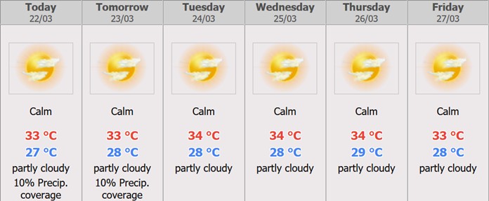
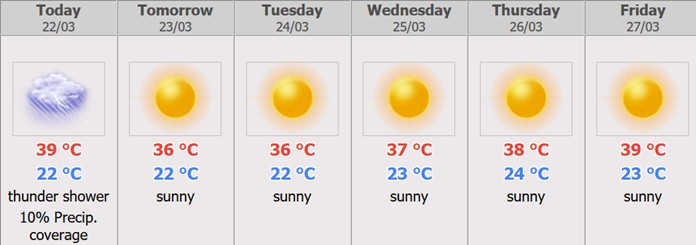
Bangkok Metropolis and Vicinity ForecastMarch 21, 2020 – March 27, 2020Day hot throughout the period with isolated rain. Minimum temperature 25-28 °C. Maximum temperature 35-39°C. Southerly wind 10-20 km/hr.
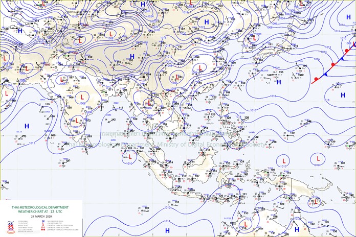
During 21 – 22 Mar, the westerly trough will move through the North and the Northeast with the southerly and the southeasterly wind prevails over the upper country where hot to very hot weather conditions. Thunderstorm with gusty wind and isolated hails are forecast for the North, the Northeast, the Central and the East. During 23 – 24 Mar, the heat low pressure cell covers upper Thailand cause hot to very hot in the upper country. The Southerly and Southeasterly wind brings moisture to the Northeast East and the East with isolated thundershowers. The weak easterly wind prevails across the South and the Gulf with isolated rain over the South.
Cautions
During 21 – 22 Mar, people in upper Thailand should beware of severe conditions.
 |
 |
 |


