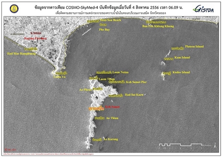
Satellite image by Geo-Informatics and Space Technology Development Agency (GISTDA), as of 4 August 2013, 0609 hrs
Further improvement has been reported in the dispersion and dissipation of the oil spill off Samet Island, Thailand, as clearly indicated in the “COSMO-SkyMed-4” Satellite image as of 0609 hrs, August 4th, 2013. The image shows the presence of only small quantities of oil film near the northern coastal area of the island. This shows that the oil spill has almost totally cleared up.
Sample tests of water, sand, air, marine life and corals in the sea off Rayong have not indicated any dangerous chemical residues. Nevertheless, the environment and ecological system in the area of oil slick will be monitored for at least 12 months, according to a minister. Vichet Kasemthongsri, Natural Resources and Environment Minister, who made a personal inspection at Phrao Bay on Samet Island yesterday (04 Aug 2013).
A big clean-up and recovery day is to be held on Ko Samet Island on Aug 10 to help regain tourists’ confidence.
TAT Rayong office together with TAT Head office will organise Agent & Media Fam Trip of about 25 people between 14-15 August 2013 to survey the area and see the progress for themselves. They will also have a chance to discuss business with the local entrepreneurs.
Tourism Minister Somsak Pureesrisak and his team have assigned “Kok Kaek Tour” a special tour package to rebuild tourism to Samet Island.
Tourism business at other beaches in Rayong such as Hat Mae Ramphueng, Hat Suan Son, and Hat Wang Kaeo has remained unaffected.
The provincial administration has set up a special centre to receive complaints from those affected by the oil spill.
About twenty beaches on Samet including with Had Sai Kaeo (Crystal Sand Beach), Ao Wong Duean, Ao Phai, Ao Kio and Ao Karang which are located on the east coast of Samet Island which is totally unaffected.


