Greening tourism and reducing the carbon footprints are high on the agenda and one of Thailand’s islands, already lush green with over 70% rain forest cover, is intent on becoming greener.
The Tourism Authority of Thailand has identified Chang Island as the key pilot project to build greener tourism where tourists can visit, confident that the impact of their travels will be minimal, based on lowering the island’s carbon footprint.
One of the important projects is a climate protection programme that is being carried out by the German International Cooperation (GIZ), Thailand’s Designated Areas for Sustainable Tourism Administration (DASTA), Thai Trat Tourism Association, the Municipality of Chang Island, Maak Island Sub-district Administration Organisation and Trat province with the support of TAT.
Started in 2009, the project focuses on Chang Island, Thailand’s third largest island rich in rain forest and surrounded by an unspoilt archipelago of islands stretching southeast to the border with Cambodia.
Chang Island is a popular tourist attraction, but there are differences from the larger island destinations of Phuket and Samui, giving its tourism industry an opportunity to carve out a market in ecotourism, while appealing to visitors who want to reduce their carbon footprint by visiting destinations that are almost carbon neutral.
Go Green Project
Thailand’s Strategic Plan on Climate Change was introduced in 2009 to maintain the island’s resource while promoting sustainable tourism that focuses on the island’s “green” assets.
To be climate friendly is a great selling point for an island destination, but the challenge is to safeguard green assets as well as build a viable tourism industry.
The programme attempts to reduce the carbon footprint in villages, hotels, resorts and restaurants across the island’s economy by involving communities.
Starting with tourism stakeholders the programme awards green leaf certification based on a reduced carbon footprint demonstrated by the various tourism enterprises. Through this effort the ultimate objective is to reduce the entire island’s carbon footprint by a few important notches.
Thailand’s Strategic Plan on Climate Change focuses on:
Provides carbon footprint management tools for tourism partners to improve standards;
Maximise public and private participation in planning and implementation of community-based management;
Training on climate change through education programmes targeting island residents;
Improve energy efficiency within communities and tourism sectors;
Develop climate-friendly marketing as a model to adopt in the tourism industry.
Activities
There are surveys that collect data and information on energy use and how the adoption of environmentally friendly fuels for transport can help the island reduce its carbon footprint.
The surveys focus on transport, food preparation, accommodation and tourist-related activities.
Data reflects the high use of energy in hotels and restaurants and this allows prorgamme staff to identify ways to make resorts greener through alternative energy sources or ways to cut energy consumption.
The island is leading the way in waste management based on a model that was designed for Phitsanulok, a major town in the lower north of Thailand. This is now being adapted for communities across the island and will lower the overall carbon footprint of the island.
Eberswalde University in Germany created the model for training programmes for three groups on the island; tourism related government officials, tourism businesses and local guide and community leaders.
Then there is a programme to teach how to use energy efficiently and profitably to improve the performance of small and medium size businesses on the island. Linked to this is a certification programme that focuses on hotels, to assist them to use renewable energy such as solar energy, biomass energy (biological material from living organisms) and wind power.
The bottom line objective is to identify the island’s carbon footprint and reduce it and based on that achievemen, the island can flag its promotions and marketing with “Go green on Chang” to visitors who would like to holiday in a destination that has adopted responsible tourism principles.
The Island
Chang Island in Thai language means Elephant Island due to its shape, which is similar to an elephant. The island is part of an archipelago of over 40 islets strung out like jewels in the Gulf of Thailand.
There are three major islands that are part of the go-green programme; Chang, Kood Island and Maak. The total area of the archipelago is 2,480 square metres and the three main islands have areas of 209 sqm. 105 sqm and 16 sqm respectively. Other islets in the archipelago are scattered over an area of 650 sq km.
Chang Island, close to neighbour Cambodia, is about 300 km southeast of Bangkok, but there are air services to the mainland airport at Trat from the Thai capital and Samui Island with connections through to Phuket and even Singapore.
Attractions
Chang Island
There are four major beaches:
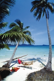
Hat Sai Khao Beach is 5.6 km from the ferry pier with a variety of resort hotels from five to three-star as well as economy-class lodges.
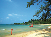
Klong Son Beach is a quiet, relaxing beach, 2.5 km from the ferry pier, at the northern tip of the island skirted by coconut plantations.
Klong Prao Beach is 9 km from the ferry pier. The beach is next to Hat Sai Khao Beach and connects to another beach called Kai Bae Beach, noted for its viewpoint to admire the sunset
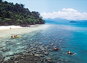
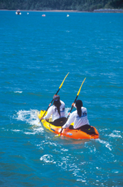
Kai Bae Beach is 13 km from ferry pier connects to Klong Prao Beach popular with international tourists and has a variety of sports activities such as bicycling, kayaking and snorkeling.
Maak Island
Maak Island stands between Chang and Kood, 38 km from Trat’s mainland. Most of the island is covered in coconut orchards and has five bays but not every bay is suitable for tourism or sports activities. The ones that have been identified as tourism assets are:
Suan Yai Bay where travellers can enjoy swimming and views of nearby islands;
Khao Bay is a great sunset beach and is suitable for swimming and fishing;
Nha Nork or Baan Yai Bay connects to Suan Yai Bay a long stretch of shoreline that is home to resort properties.
Kood Island
Kood Island is the last island on the east coast of Thailand. It is the second largest island after Chang Island in Trat province and fourth nationally after Phuket, Samui and Chang Island.
It has beautiful forested mountains, waterfalls and beaches. The most famous waterfall is Klong Chao, which cascades from a lofty ledge all year round.
There are numerous beaches on the island that are suitable for camping, but many of them have been closed off for the use of exclusive resort properties.
Chaak Bay is 500 metres long with coconut plantations. It is the most beautiful spot to watch the sunrise.
Yai Gerd Bay is on the eastern side of Kood Island. It is 800 metres long and has a white sandy beach.
Hat Klong Yai Kee Beach is on the west side of the island. The beach offers access to Klong Yai Kee Waterfall.
Klong Hin Beach is on the western side of the island. The beach is just 300 metres and it has crystal clear water that is suitable for swimming and diving especially off Klong Hin Cape;
Hat Prao Bay is also on the west side of the island and is 800 metres long, suitable for swimming and camping.
Activities on the Island
All the islands offer sports activities such as kayaking, cycling scuba diving and fishing.
Kayaking is very popular on Chang Island. There are many canals that connect to the sea offering perfect conditions to develop skills safely on calm water.
Cycling near the beaches on trails and lanes offers stunning views, but the bicycle is also a great form of transport to get from one resort to another, although the going can be tough on the hilly section once you leave the coastal trails.
Transportation
Chang Island is in Trat province 316 km from Bangkok. Bangkok Airways serves Trat airport from Suvarnabhumi Airport, twice daily.
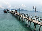
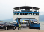
Chang Island is 5.2 km off the coast of Trat province with ferry services for both passengers and cars.


