LOP BURI, Sept 30 – Thai Army chief Gen Prayuth Chan-ocha is inspecting provinces upriver from Bangkok as continuing rains in many areas complicate an already difficult flood situation.
Prior to his inspection trip to flood-hit areas of Lopburi on Friday, Army chief Gen Prayuth Chan-ocha said that he ordered deployment of additional boats and 12 mobile medical units from the Phramongkutkhlao Military Hospital to help flood victims.
Gen Prayuth said that resident should not dispute the authorities’ decisions to divert water in whatever area, as some areas must be protected, particularly business districts and centres to provide help to other areas.
Thailand’s northern province of Chiang Mai was still under water as some areas were hit with more than one metre deep flooding, and several districts of the Thai capital are warned of possible flooding in the coming days.
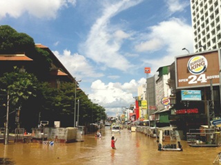
Chiang Mai’s major commercial area is still inundated with water over a metre deep, with many streets in Chiang Mai municipality, especially Chang Klan Road, where at least 10 hotels and the famous night bazaar are located, under 50-70 cm of water.
Many riverside communities along the Ping River and lowland areas were flooded with the flood over one metre high and spreading into other areas, but the Ping River was gradually receding 4-5 cm per hour on average.
Meanwhile, military engineers from the Armed Forces Development Command (AFDC) and engineers from the Royal Irrigation Department began repairing the dyke at the Bang Chom Sri water sluice gate at Sing Buri’s In Buri district.
Heavy machinery moved rocks into metal nets which were dumped at the sluice gate to tame the strong tide of water within 15 days.
The dyke failed Sept 13, unable to withstand the strong Chao Phraya River currents, causing flooding in Sing Buri and nearby Lop Buri provinces.
In other development, Dr Anon Sanitwong na Ayutthaya, acting director of Thailand’s Geo-Informatics and Space Technology Development Agency (GISTDA) referenced satellite images warning that 13 areas of Bangkok are at risk of flooding in the coming three to five days.
The 13 areas are Nong Kang Plu, Tung Song Hong, Sai Mai, Kong Thanon, Anusawaree, Jorakae Bua, Lad Phrao, Klong Kum, Klong Jan, Hua Mark, Saphan Sung, Klong Song Ton Nun and Lad Krabang.
Bangkok’s adjacent provinces of Nonthaburi, Nakhon Pathom, Samut Prakan and Chacheongsao are also at risk of flooding. Residents are urged to closely monitor the water situation as well as prepared for possible evacuation.
The Meteorological Department early Friday issued its fifth typhoon warning, downgrading Nesat to tropical storm status over the Gulf of Tonkin, with maximum sustained winds of about 100 km/hr moving west-northwest at about 18 km/hr.
The storm is expected to make landfall over northern Vietnam today.
The warning said the active southwest monsoon prevails over the Andaman Sea, southern Thailand and the Gulf of Thailand. Isolated heavy rain remains over the east and the south west-coast, especially in Nakhon Nayok, Chanthaburi, Trat, Ranong, Phang-nga, Phuket, Krabi, Trang and Satun. Residents along foothills, near waterways and in lowland areas are warned of possible flash floods.
Wind and high waves are forecast in the Andaman Sea and the upper Gulf, with the waves expected to reach 2 to 4 metres high. All ships should proceed with caution and small boats keep ashore.
Military vehicles are being used to transport children to school and local residents to their workplaces, and military aircraft have distributed flood relief supplies to victims in remote areas. Patrol boats have been sent to deliver emergency information in otherwise inaccessible areas, inform the public about news and to distributing emergency radios to residents of flood-stricken areas.


